Incorporating Nature-Based Solutions to Manage Flooding: Transforming Bengaluru’s Manyata Tech Park
The stormwater drain carrying water from Rachenahalli Lake in Manyata Tech Park. Photo by Namitha Nayak
Manyata Tech Park, an IT hub in north Bengaluru, floods every time it rains heavily. In an article in the Deccan Herald, we had explained how nature-based solutions (NbS) can not only mitigate flooding in the 300-acre campus but also restore ecological balance, reduce urban heat, improve water quality, and make public spaces more vibrant.
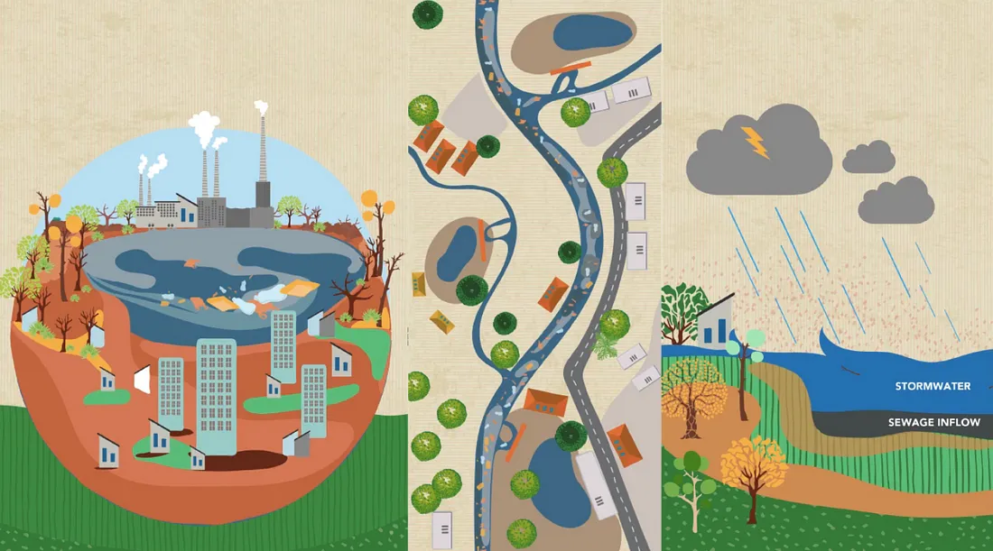
In this blog, we shall build upon that analysis to assess how we can incorporate NbS into the built infrastructure and model the benefits they could provide. Such modelling exercises to quantify their impact could help cities across India plan for, protect, and invest in NbS to improve water security and resilience. The process of modelling the benefits of NbS is as follows:

Modelling how NbS can alleviate water-related challenges. Illustration by Anam Husain
We began by mapping Thanisandra ward, where Manyata is located, using remote sensing and other data layers in QGIS, an open-source cartographic software.
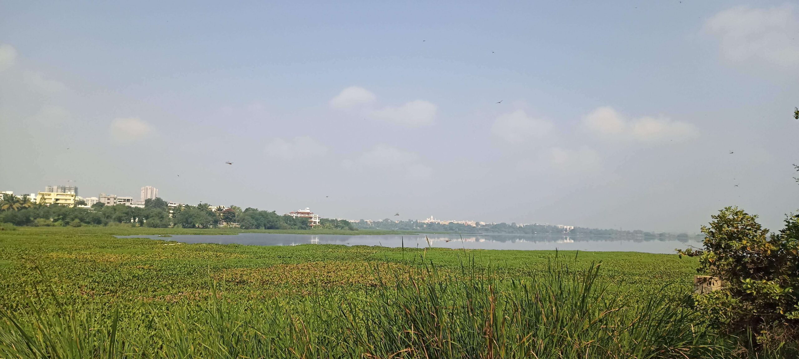
The land use and precipitation data [see Footnote 1 for details] revealed that Thanisandra has one of the highest amounts of stormwater runoff in the city—about 3 million litres per day from Manyata alone. The elevation data showed that Manyata is in a low-lying area receiving inflows from the higher-elevation regions to the north and west. The two primary stormwater drains in Manyata carry the discharge from two lakes, Nagavara and Rachenahalli. Parts of these drains have a negligible downhill, and even slightly uphill, slope, causing water to stagnate. Owing to these geographical features, people grew paddy in the region before Bengaluru rapidly urbanised.
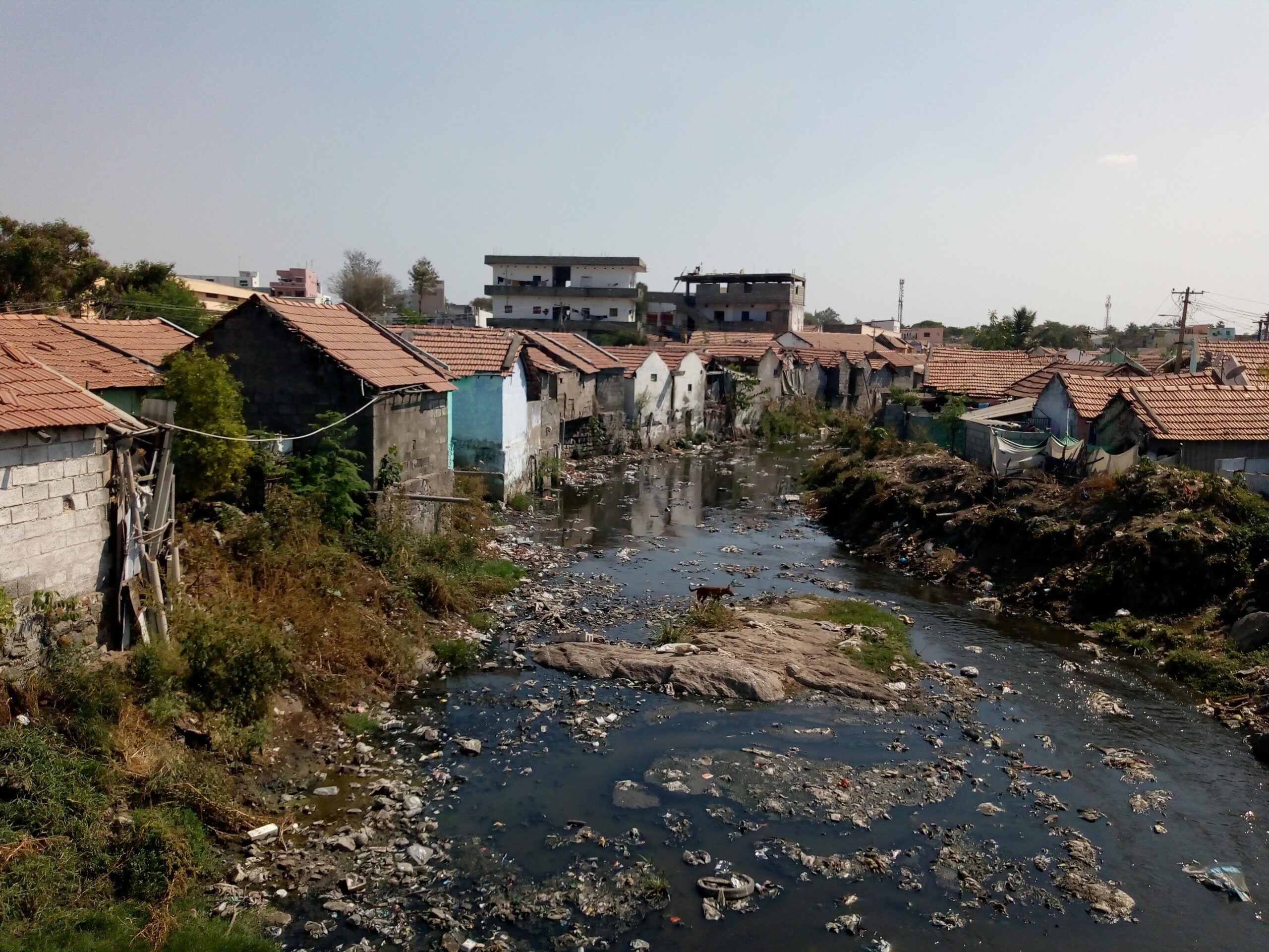
We met with officials of the Manyata Tech Park to understand how they manage water. They claimed that the drain from Nagavara Lake carries garbage, which they remove regularly. Nevertheless, waste accumulates in the drain upstream and downstream of Manyata, blocking water flow. They added that some of the drains surrounding the property have been encroached upon [2]. When the area floods, they use pumps to drain the water.
Groundwater depletion is also an issue in Thanisandra, as a 2025 study by the Indian Institute of Science and a 2020 paper by Tomer et al. demonstrate. We overlaid the data from both studies on QGIS and found that groundwater depletion in the area is in the range of 4.3 to 6.4 million litres per day. The region also has a large built-up area and less vegetation, which compounds water challenges and leads to higher temperatures.

The stormwater drain from Nagavara Lake is choked with garbage, impeding water flow through the Manyata Tech Park. Photo by Kaylea Brase Menon

Visual from QGIS showing Manyata Tech Park (outlined in red). The blue dotted lines represent primary drains. Map by Shashank Palur
We selected suitable NbS strategies to address the challenges in Manyata Tech Park.
To reduce runoff, we can incorporate the following solutions in the area:
1. Infiltration trenches
2. Permeable pavements
The above two interventions reduce runoff by increasing groundwater recharge, which also addresses the problem of groundwater depletion.
3. Green roofs
4. Retention tanks
They reduce runoff by storing water for reuse or in recharge wells.
We also selected rain gardens and bioswales as they increase groundwater recharge and improve the water quality by filtering stormwater.
With OpenStreetMap, we identified the locations where nature-based solutions can be implemented:
- Rain gardens under flyovers and in traffic islands.
- Retention tanks to hold water in road dividers.
- Infiltration trenches, permeable pavements, and bioswales along roads.
- Green roofs on top of the 31 buildings in Manyata.
- Retention tanks or detention basins on the undeveloped land.
See the table below for details regarding the total number, area, and impact of these NbS.

An overview of the challenges and proposed solutions in Manyata Tech Park. All infographics by Anam Husain
")
Nature-based solutions can be integrated into the built infrastructure to reduce flooding and the urban heat island effect
")
")
Street-level views of Manyata Tech Park showing where nature-based solutions can be integrated
We then used the Storm Water Management Model (SWMM) software to quantify the impact of NbS projects in Manyata [3].
The software can be used to simulate an NbS intervention’s response to different rainfall intensities. It requires input parameters for the area being modelled, such as soil characteristics, elevation, and infiltration rates. It also requires parameters for the NbS design, such as the engineered soil characteristics (strength, permeability, compressibility, etc.), area, and storage depth. These parameters were determined based on the land use, a secondary literature review, the SWMM manual, and NbS design guidelines.
We simulated a storm on 18 May 2022, which saw 119 mm rainfall over 12 hours and had a peak intensity of 90 mm/hour [4]. It caused flooding not only in Manyata but across Bengaluru [5].
The simulations showed that NbS interventions in Manyata can:
- Reduce runoff by a quarter (from 105 mm to 80 mm).
- Increase groundwater infiltration by 45% (from 12 mm to 17.4 mm).
- Reduce pollutants in the runoff by half (from 176 kg to 92 kg).
Together, these interventions can manage 20.6 million litres of water during the simulated storm event. They would also reduce the flood volume by half, from 9.5 million litres to 4.9 million litres. Given that Manyata currently relies on pumping out water to alleviate waterlogging, NbS could significantly reduce the time and cost of pumping.
| NbS Type | Number of NbS | Total Area (sq. km) | Location | Water managed (Litres) | Rainfall Capture | Pollution Reduction | Runoff Reduction | Groundwater Infiltration Increase |
|---|---|---|---|---|---|---|---|---|
| Green Roof | 31 | 179,800 | Buildings | 12,316,000 | 57.8% | 41% | 14.3% | 0% [6] |
| Infiltration Trench | 10 | 8,440 | Along streets | 1,000,140 | 100% | 3.5% | 1.1% | 9.7% |
| Permeable Pavement | 3 | 22,150 | Along streets | 2,624,775 | 100% | 8.3% | 3.2% | 28% |
| Rain Garden | 5 | 7,300 | Traffic islands, under flyovers | 865,050 | 100% | 3.2% | 1.2% | 7.2% |
| Retention Tank | 3 | 31,000 | Open spaces | 3,673,500 | 100% | 6.6% | 4.4% | 0% [7] |
| Bioswale | 3 | 3,000 | Along streets | 119,700 | 33.7% | 1.4% | 0.2% | 0.4% [8] |
| Total | 55 | 251,690 | 20,599,465 | 69.1% | 52.4% [9] | 24.4% | 44.9% |
Analysis of hydrological benefits of NbS proposed for Manyata
While the model shows strong potential for flood mitigation by incorporating NbS in Manyata Tech Park, it has certain limitations.
The model currently does not delve into the depths of waterlogging on roads and the reduction in flood duration. To estimate these, it needs to be upgraded with a more precise digital elevation model and exact measurements of road widths, stormwater drain depths, and the extent of silting.
Another aspect we need to consider is the broader dynamics of the catchment—the inflow from lakes, untreated wastewater from unsewered connections, and runoff from adjacent built-up areas [10]. Factors such as soil composition, maintenance, and actual infiltration performance during continuous storms further impact on-ground outcomes.
Next, we shall calibrate the model with on-ground measurements of soil characteristics and infiltration capacity.
We shall also verify the feasibility of our proposed NbS designs during site visits to Manyata. The model can be calibrated with flow measurements of actual NbS interventions in a similar area to make the simulation more precise.
Scaling the model across flood-prone Bengaluru wards could shape a city-wide NbS roadmap.
For the roadmap to be effective, we must invest in baseline data, cross-agency coordination, and pilot projects. The Government of Karnataka’s collaboration with the World Bank on the Karnataka Water Security and Resilience Programme provides a unique window to scale NbS across the city. They are investing $180 million and $426 million, respectively, to build and revamp stormwater drains, construct nine sewage treatment plants, and rejuvenate lakes. Incorporating NbS along with grey infrastructure in this project can help Bengaluru better address recurring floods.
WELL Labs’ report Barriers to Mainstreaming Nature-based Solutions in Urban India [11] highlighted that one of the main challenges with regard to NbS was the lack of evidence from the Indian context. The Manyata Tech Park case study shows how we can design NbS for Indian urban landscapes and quantify their impact. Modelling exercises like these can also help direct funding towards such interventions, as the lack of evidence regarding their effectiveness and returns on investment deters the private sector and philanthropies from funding them.
Footnotes
[1] The Karnataka State Natural Disaster Monitoring Centre shared the precipitation data from 2022 with us.
[2] Encroachments on water bodies and stormwater drains are a problem across Bengaluru. While we need to address encroachments as part of the larger watershed management plan to reduce flooding, NbS can additionally contribute to these water-resilience initiatives.
[3] We were guided by case studies that modelled NbS interventions for Nagpur and Bengaluru, India.
[4] This figure is from the precipitation data of the Karnataka State Natural Disaster Monitoring Centre.
[5] We selected this storm event for the modelling exercise as it is representative of the kind of storm that floods Manyata Tech Park. It was a once-in-two-year storm, that is, a storm of that intensity is likely to recur every 2 years or has a ‘return period’ of 2 years (see Page 121/151 of the report Bengaluru Stormwater Drains Master Plan 2010 for more information regarding return periods for Bengaluru). While city planners typically build standard infrastructure to withstand storms with return periods of 10–25 years, many parts of Bengaluru are unable to withstand storms of much lower intensities and get flooded.
[6], [7] Both green roofs and retention tanks store water, thereby reducing runoff. While this stored water could potentially be used for groundwater recharge, we haven’t modelled for this scenario.
[8] While bioswales can store 87,000 litres of water and recharge up to 32,700 litres, the overall impact of bioswales on groundwater recharge across Manyata is minimal.
[9] While the pollution reduction percentage of each intervention adds up to 64%, the combined pollution reduction is 52% because green roofs capture some pollutants that would otherwise have flowed into the other NbS.
[10] Managing these dynamics of the wider catchment would require interventions beyond NbS, such as keeping waterways free from garbage and regulating water flows by building sluice gates and monitoring water levels in upstream lakes.
[11] We produced the report in collaboration with the Oak Foundation and Rocky Mountain Institute.
Acknowledgments
Editor Syed Saad Ahmed
With inputs from Shashank Palur and Shreya Nath
Published by Nanditha Gogate
Follow us and stay updated about our work
Related Posts
Related Posts
-
Why We Need Urban Water Balances
We explain the need to better understand how water moves through cities and illustrate effective ways to visualise urban water balances.
-
Setting the Context — Water Governance in Bengaluru
In this series, we explain the need to better understand how water moves through cities and illustrate effective ways to create and visualise urban water balance through the case of Bengaluru.
-
Understanding Wastewater Reuse: 5 Learnings from the IWA International Conference
Our Urban Water team sums up five key learnings on wastewater treatment and reuse from the five-day IWA conference held in Chennai in January 2023.
-
Soak Up the Rain: How a ‘Sponge City’ Makes Urban Areas Climate Resilient
In Part 1 of this blog series, we introduce the concept of sponge cities and how this Nature-based Solution has become a popular flood mitigation strategy.
-
A Visionary Architect and a New Growth Model: What’s Behind the Rise of Sponge Cities in China?
In Part 2 of this blog series, we delve into how one man’s vision and coupled with reforms by the Chinese government led to the nationwide adoption of nature-based solutions to manage floods.
-

Beyond the Jargon: 10 Key Takeaways from World Water Week 2023
WELL Labs Executive Director, Dr. Veena Srinivasan, led sessions on water and agriculture at World Water Week 2023, an annual event on global water issues organised by the Stockholm International W...