Can Recharge Pits Address Waterlogging and Drought in Marathwada? | Initial Insights
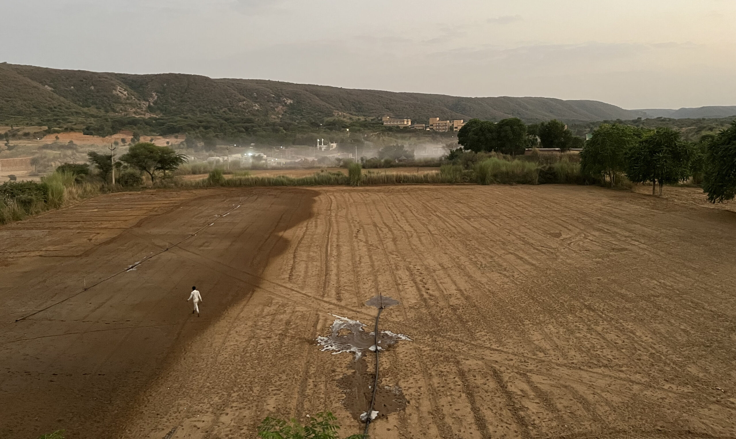
An aerial view of Jalna. Photo credit: Manram Collective
This is the first installment of a two-part blog series detailing our findings from a monitoring and evaluation study of recharge pits in Jalna.
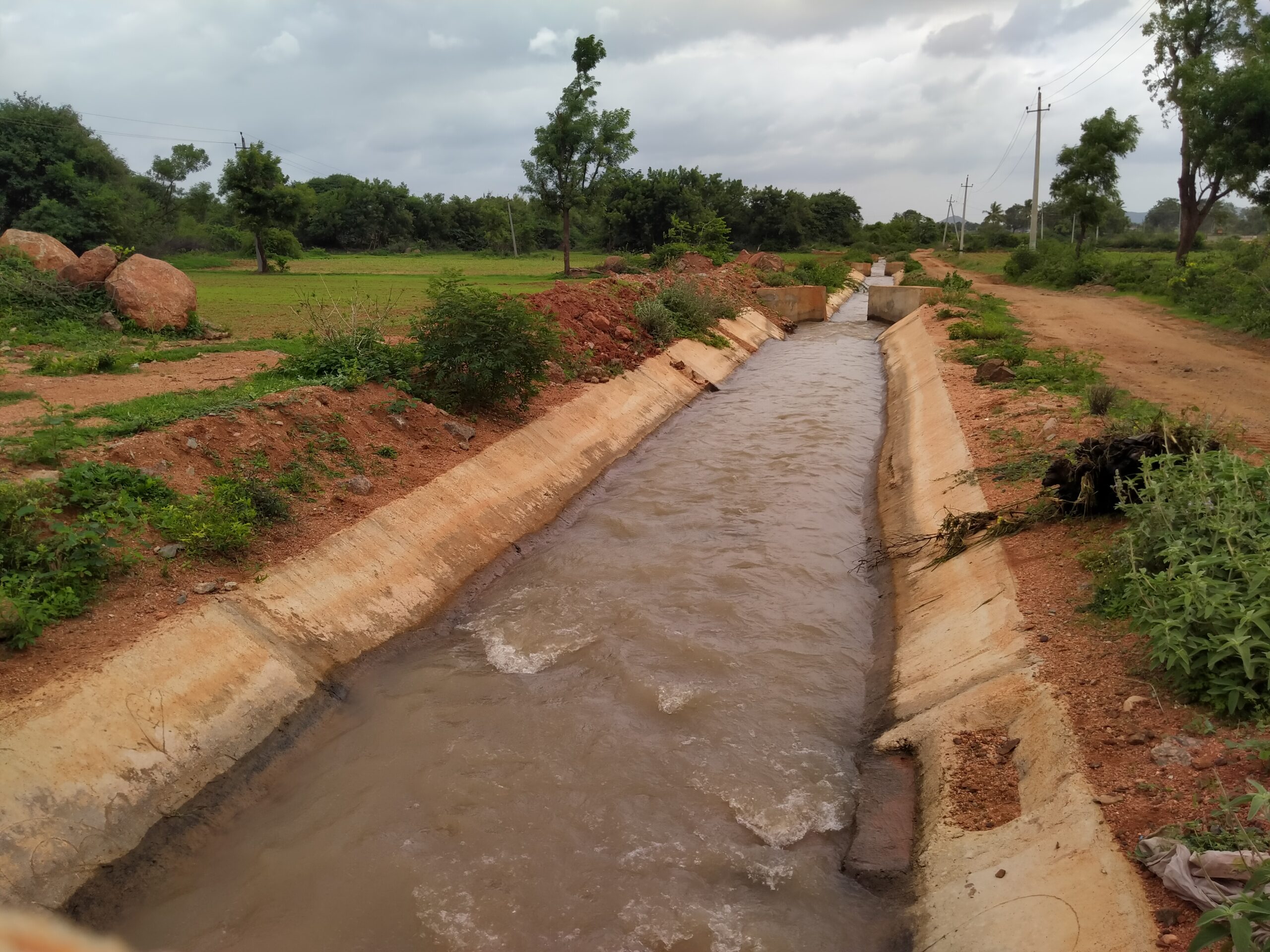
Every year, farmers in Maharashtra’s Marathwada region are forced to contend with two extreme weather events—droughts and floods—made worse by the low permeability of its black soil. Infiltration pits play an important role in addressing these challenges by reducing waterlogging in agricultural fields, controlling soil erosion, and recharging groundwater. However, they come with their own sets of challenges.
WELL Labs and Environmental Defense Fund (EDF) are conducting a monitoring, evaluation, and learning (MEL) exercise to assess the socio-hydrological impacts of one such infiltration pit called ‘JalTara’.
In 2021, Save Groundwater Foundation (SGF) introduced the JalTara initiative in Jalna district to address water management challenges. The intervention focuses on constructing infiltration pits that enable water to bypass the low-conductivity black soil and penetrate the underlying layer of weathered rock.
Read | Why Jalna’s Wells Run Dry: Understanding Water and Soil in Drought-Prone Maharashtra
The Design and Functionality of JalTara Pits
Each JalTara pit measures 4x4x6 ft, and is filled with boulders at the bottom and murum (powdered laterite rock) towards the top (Fig. 1) to create a high-conductivity pathway for the water. It is designed such that farmers can continue using the surface area for cultivation. The cost of constructing each pit is approximately ₹1,600, including the rental for an earth-moving machine, and SGF recommends farmers have one pit per acre for maximum efficiency.
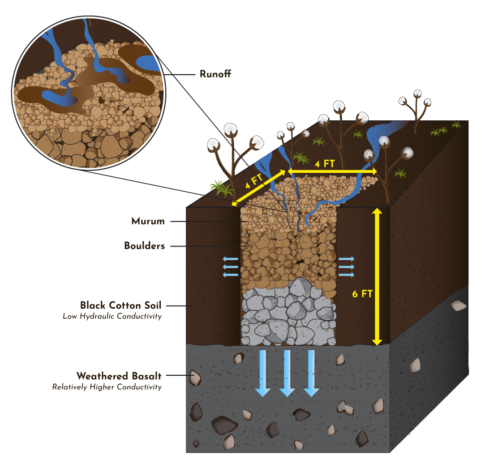
Fig. 1: Schematic representation of a JalTara pit.
SGF has helped construct approximately 60,000 JalTara pits (Fig. 2) across two blocks in Jalna with the aim of addressing two critical challenges: reducing waterlogging in agricultural fields and replenishing aquifers in this drought-prone region.
Given the substantial financial investment and the theoretical benefits, we are conducting a thorough assessment of the intervention to evaluate its effectiveness at both the individual pit and watershed levels.
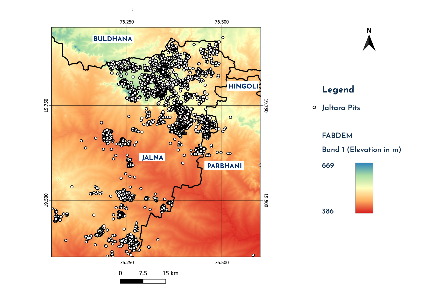
Fig. 2: Approximately 60,000 JalTara pits have been constructed in Jalna since 2021.
Evaluating the Impact of JalTara: Hypotheses and Methodology
We formulated four hypotheses to determine JalTara’s effectiveness. The first three focus on evaluating its impact at the field scale, while the fourth examines its effect on groundwater levels at the watershed scale.
| Hypothesis | Primary Approach | Results |
| 1: JalTara pits have a significantly higher infiltration rate per unit area than the surrounding fields. | Field infiltration experiments: Double-ring infiltrometer test for on-farm and top-of-pit. | Pits did not exhibit any significant increase in infiltration rates compared to on-farm infiltration rates. |
| 2: Water ponding in fields has reduced where JalTara has been implemented. | Farmer interviews: Farmers with and without JalTara were interviewed through a semi-structured survey. | Farmers with JalTara pits reported benefits such as lower crop loss. |
| 3: At least 25% of excess runoff within that acre can percolate down via the pits. | Data analysis and modeling: To estimate hydrological partitioning at plot scale. | Ongoing |
| 4: Water levels improved at a watershed level as a result of JalTara. | Paired watershed approach: To assess watershed-scale impact of JalTara pits on groundwater levels. | Ongoing |
Read | Unpredictable Rainfall Makes Farming in Marathwada Even Harder
Initial Learnings from the Evaluation
The M&E is an on-going study. While work on the first two hypotheses is complete, the data collection for the third and fourth is in progress. Here’s a summary of our findings so far:
Hypothesis 1: Infiltration Rates
Infiltration tests were conducted both on-farm and at the top of the pits to compare their effectiveness. On-farm tests served as a baseline, while tests at the top of the pits evaluated the infiltration capacity of the porous murum. Sampling was strategically spread across 22 pairs in three elevation ranges to capture soil thickness variability. However, despite the design’s intent, the pits failed to outperform the surrounding fields in infiltration rates due to siltation.
Key Observations:
-
- There wasn’t a drastic change in infiltration rates due to siltation. On-pit infiltration rate was a median of 8.4 cm/hr, while on-farm was 7.7 cm/hr.
- Pits constructed in 2023 had higher infiltration rates (median: 11.5 cm/hr) than those from 2022 (median: 3.3 cm/hr), highlighting performance decline over time due to silt accumulation.
- The pits are located at the lowest point of the farm, adjacent to the farm bund, to capture and retain more water. However, this also leads to an increase in silt accumulation.
- Pits that didn’t receive substantial runoff exhibited 3-7 times higher infiltration rates than on-farm conditions. This emphasises the need for better pit placement.
- Maintenance gaps and design flaws in silt-trapping mechanisms compromise long-term functionality of the pits.
- Soil erosion adds to siltation of the pits.
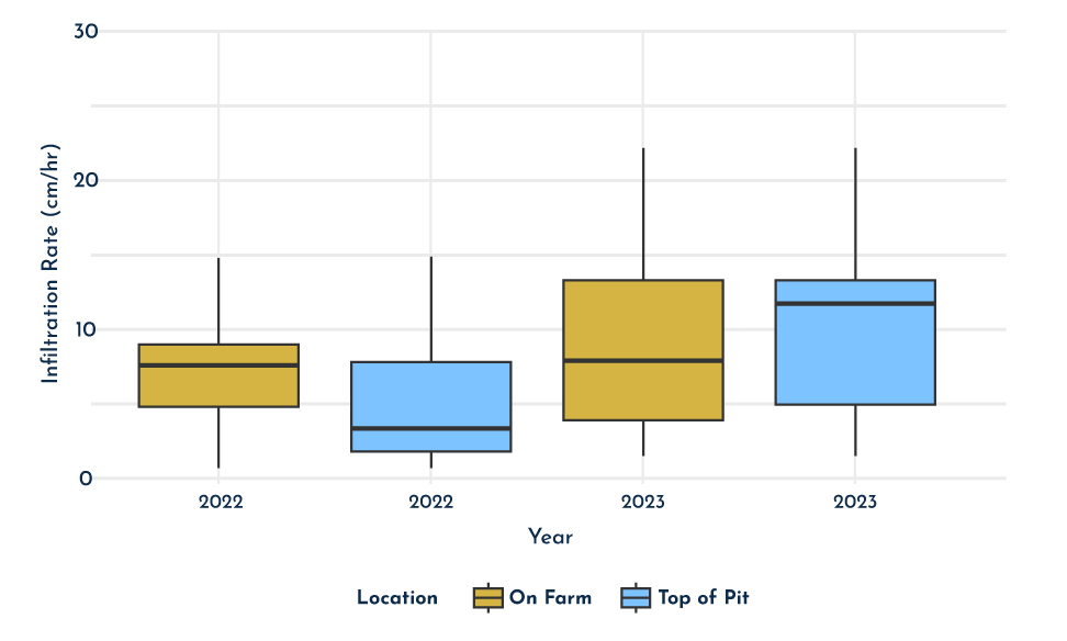
Fig. 3: A comparison of infiltration rates between on-farm and the top of the pit for 2022 and 2023.
Insights on Method Application:
We evaluated the effectiveness of JalTara pits using a double ring infiltrometer. Initially, we recorded the reduction in water levels due to infiltration at specific intervals (constant time method). However, we noticed that the infiltration rate was significantly higher when there was more water in the infiltrometer, and lower as the water level dropped. This variability suggested that fluctuating water levels could lead to inaccurate results. To address this, we switched to the constant head (water level) method, which maintains a steady water level throughout the test. This approach provided more reliable data on infiltration rates, allowing for a better comparison between the infiltration rates at the top of the pit and those on the farm.
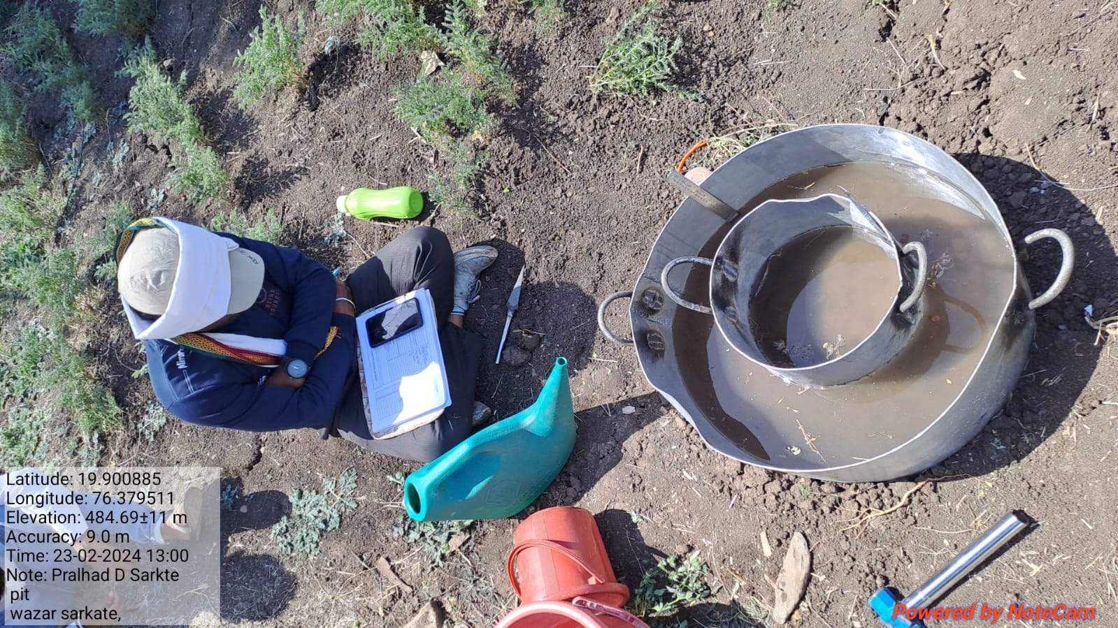
Fig. 4: Double-ring infiltrometer experiment on pit.
Hypothesis 2: Crop Loss Reduction
A survey of 155 farmers revealed that crop losses were significantly lower in farms where JalTara pits were newly installed. Fig. 5 compares farms with pits (treatment) and those without pits (control) during 2022, a year with near-normal rainfall of 724 mm. Crop loss in farms with JalTara was significantly lower (10%) compared to farms without the pits (63%).
Insights from Farmer Surveys:
-
- Pits helped reduce waterlogging and ponding, directly correlating to improved crop survival.
- Farmer-reported data revealed recall bias, emphasising the need for more robust historical validation.
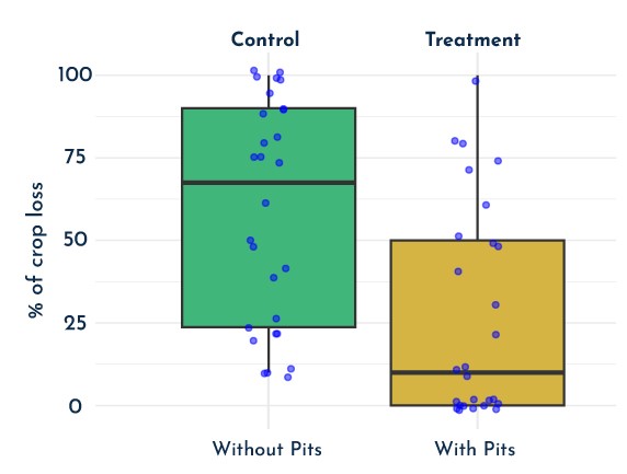
Fig 5: A comparison of percentage crop loss reported in 2022 by pit owners (yellow) and non-pit owners (green).
Insights on Method Application:
Monsoon in any given year significantly influences the effectiveness of infiltration pits. For instance, a year with a rainfall deficit, like 2023 with only 400 mm, may give a false impression of JalTara’s effectiveness. For M&E, comparing data from the same season and similar hydrological conditions yields more reliable results. While farmer surveys were used to collect historical data, we expect low accuracy and potential confirmation bias since they relied on memory recall.
Preliminary Conclusions and Future Directions
Across India, infiltration pits—commonly referred to as dug-out ponds, recharge basins, or contour trenches—are designed to reduce soil erosion and recharge groundwater. Their structure varies based on soil type and aquifer characteristics, and is often integrated with other watershed treatments.
Based on our M&E study of the first two hypotheses, JalTara pits could help mitigate waterlogging and enhance groundwater recharge in low-conductivity regions, if certain limitations are addressed.
| Limitations | Possible Solutions |
| Siltation and clogging over time. | Improved design for silt trapping. |
| Insufficient maintenance. | Increased farmer awareness to do regular pit maintenance. |
The final results of the study will be shared in the next part of this series. Stay tuned for Part 2, where we assess JalTara’s impact on groundwater recharge and watershed health!
Authored by Ishita Jalan and Lakshmikantha NR
Technical inputs by Gopal Penny
Edited by Ananya Revanna and Jonathan Seefeldt
Published by Ananya Revanna and Saad Ahmed
If you would like to collaborate, write to us. We would love to hear from you.
Follow us and stay updated about our work:

